The Geography of the USA
The United States, located in North America, is a vast territory comprising 50 federal states and one district. The country is bordered by Canada to the north and Mexico to the south.
The United States, located in North America, is a vast territory comprising 50 federal states and one district. The country is bordered by Canada to the north and Mexico to the south. Its geographical structure follows an east-west gradient pattern. The entire territory covers an area of approximately 9,631,417 km², divided into three major regions: the Mainland (over 7 million km²), Alaska (nearly 1,100,000 km²), and Hawaii (approximately 28,000 km²).
General Characteristics
The United States is 20 times the size of France. It is the 4th largest country in the world, after Russia, Canada, and China. It spans multiple time zones, including Hawaii and Alaska. With a rich natural heritage, each geographical zone of the country possesses its own distinct characteristics. The vastness of the territory reveals an endless variety of landscapes formed by mountain ranges, vast forests, lakes, beaches, canyons, and deserts.
The Relief of the United States

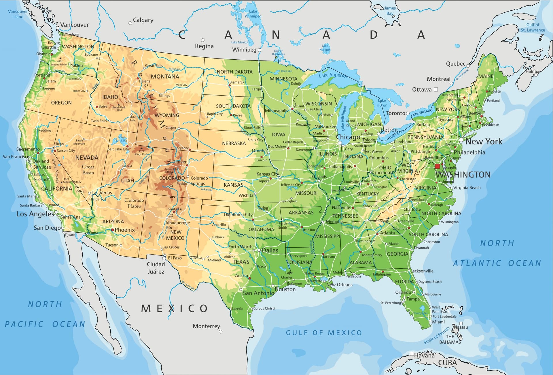
The American relief is organized like parallel bands stretching north-south and presents itself in the following manner.
The eastern part reveals coastal plains marking the arrival of Europe's first colonists. This led to the birth of the Megalopolis, a cluster of urban areas such as Boston, New York, Philadelphia, Baltimore, and Washington.
The Midwest, or intermediate west, features the Appalachian Mountains that reach toward the Great Plains around the Mississippi. Beyond this great river lies the Far West, where the Rocky Mountains rise majestically—an impressive chain of peaks sometimes carved with great basins, like those found in Colorado.
The relief ultimately reaches the Pacific coastal plains, bordered by sierras with significant elevation changes.
The Major Regions of the United States
Geographically speaking, American territory is subdivided into four major areas. Here are all the details relating to this division.
The East Coast
It is bordered by the Atlantic Ocean and runs along a coastline stretching from Canada to Florida. Considered the historical cradle of the United States, here are the regions generally encompassed by the East Coast:
New York, capital of the American dream, maintains its popularity with its towering skyscrapers;
New England, grouping typical villages and forests with changing seasons;
The eastern part of North America extending to central Alabama, home to the mighty Appalachian Mountains with their lush peaks and countless valleys;
The Canadian border where rich wildlife can be discovered. Further north lie Niagara Falls.
The West Coast
This refers to regions in western United States bordering the Pacific Ocean, stretching from California in the south to Washington in the north. Southern California's extreme regions display desert-like relief with cacti forests. Los Angeles is partly surrounded by the coast and marked to the east by the Sierra Nevada mountain range, as well as spectacular canyons. Further north are Oregon and its vast forested territory, composed of conifers, countless lake sites, and high plateaus.
Northern United States
Marked by the interior and northern Great Plains, this portion of the United States is bordered to the west by Yellowstone Park, extending into Idaho, Montana, and Wyoming. It also includes the Appalachian Mountains and the Rocky Mountains massif, separating New Mexico and Montana. This zone is also home to the great natural lakes and waterways that drain much of the Great Plains.
Southern United States
Southern United States comprises, besides vast vineyards, highly fertile plains where extensive fields of tomatoes and citrus fruits stretch across the landscape. The Southeast includes, among others, the states of Florida and Louisiana. These regions are now among the most visited territories in the country, thanks to development projects. Florida is characterized mainly by the long beaches of Miami, the Florida Keys archipelago, and the Everglades region. Meanwhile, Louisiana displays the character of a colonial era blended with rich nature, largely composed of sugar cane plantations.
The Southwest indicates the states of Texas and New Mexico. An arid and desert-like landscape can be observed here, while offering an excellent view of the White Sands Desert. Continuing toward Arizona, Utah, or Nevada, the scenery transforms into fly geysers or endless rows of cacti.
The Main Rivers of the United States

Mississippi: measuring 3,780 km long, this river traverses the central part of the United States, passing through ten states. It flows from northern Minnesota to the Gulf of Mexico.
Colorado: at 2,330 km long and located in the southwestern United States, it marks the boundary between Nevada and Arizona, then California and Arizona. This waterway originates in the Rocky Mountains and flows into the Gulf of California, passing through the states of Colorado, Utah, and Arizona.
Rio Grande: with its 3,037 km, it is the 2nd longest river in the United States after the Mississippi. The river originates in Colorado, passes through New Mexico, then diverts to the southeast, serving as the border with Mexico where the river is known as Río Bravo.
Arkansas: this designates a tributary of the Mississippi, flowing through the states of Colorado, Kansas, Oklahoma, and Arkansas. It originates in the Rocky Mountains and flows into the Mississippi. Reaching 2,334 km in length, it is the 4th longest waterway in the United States and represents an important hydrographic resource.
Ohio: this river, measuring 1,579 km, flows in the eastern United States. It traverses the states of Illinois, Indiana, Ohio, New York, Pennsylvania, Maryland, West Virginia, Kentucky, Tennessee, Virginia, North Carolina, Georgia, Alabama, and Mississippi. It continues northwest before ultimately flowing southward.
Columbia: its upper course is located in the Canadian Rockies. Measuring 2,000 km, it is the largest river by volume flowing into the Pacific Ocean in North America.
Tennessee: being the main tributary of the Ohio, it flows through the Tennessee Valley located in the southeastern United States. With a length of approximately 1,000 km, it connects with the Mississippi basin.
Snake River: this river, taking the form of a serpent, flows in the northwestern United States. It measures 1,670 km long and is the longest tributary of the Columbia River.
Lakes in the USA
The United States contains 5 great lakes situated between the border zones of the United States and Canada. They extend over a total area of 245,000 km², equivalent to half of France, including:
Lake Superior (82,103 km²): the deepest of the 5 lakes with 406 m and the world's largest freshwater lake. Two-thirds is located in the United States and the remainder in Canada.
Lake Ontario (19,011 km²): it is bounded to the north by Canada and to the south by the state of New York. The lake connects with the others through a canal called Welland as well as through Niagara. Elongated in shape, it represents the smallest of the 5 great lakes.
Lake Huron (59,600 km²): taking the form of two pockets, the lake is shared between the United States and Canada as it sits in the heart of North America. Its course begins by receiving the waters of Lake Superior and the Strait of Mackinac, ending its journey in Lake Erie.
Lake Erie (25,700 km²): it is the shallowest of the 5 lakes, reaching a maximum of 64 m in the deep trenches. It ranks as the 13th largest natural lake in the world. Receiving waters from Huron through Lake St. Clair, it flows into Ontario via the Detroit River and Niagara Falls.
Lake Michigan (57,750 km²): it is located in northern United States, west of Lake Huron and south of Lake Superior. The Strait of Mackinac constitutes its main outlet, allowing connection to the four other lakes. A canal links it to the Mississippi River, leading to the Gulf of Mexico. Furthermore, it is the only lake situated entirely within United States territory.

Other Lakes
Certain states within the American union possess significant water reservoirs, among which can be found:
the Great Salt Lake, located northwest of Salt Lake City in Utah;
Lake Pontchartrain, a saltwater lake southeast of Louisiana;
Powell, held back by the Glen Canyon Dam, an artificial lake created on the Colorado River;
Utah Lake, situated in northern Utah near the cities of Provo and Orem;
Tahoe, a great alpine lake of North America with 501 m of depth, bordering California and Nevada;
Mead, the largest water reservoir and major artificial lake in the United States, located between Nevada and Arizona;
Lake Almanor, situated in Plumas County in northeastern California, formed by a 40 m high hydroelectric dam.