Death Valley National Park USA: the main points of interest
Nestled in the foothills of the Sierra Nevada, Death Valley is one of the hottest places on the planet.
Nestled in the foothills of the Sierra Nevada, Death Valley is one of the hottest places on the planet. While the living conditions may seem inhospitable at first glance, the park contains a multitude of landscapes that are equally spectacular... We'll take you on a discovery of the most beautiful sites to visit in Death Valley!
Death Valley National Park: an overview of its history and distinctive features
Death Valley is located within the national park of the same name, which spans over 13,600 km². This exceptional size makes it the second largest national park in the United States. Within this vast territory, straddling Nevada and California , Death Valley itself covers 7,800 km²!
The Death Valley National Park belongs to the Basin and Range geological region, and more specifically to a "physiographic" zone: meaning it features great geomorphological diversity with varied topography (canyons, grabens, horsts, etc., resulting from tectonic movements).
This geomorphological richness harbors (or harbored) numerous minerals, such as borax, copper, talc, silver, and especially gold. The latter was particularly coveted between 1848 and 1856, during the "Gold Rush." The name "Death Valley" stems from this era, when members of an expedition lost their lives in this arid region.

What are the must-see sites to visit in Death Valley?
Death Valley has about twenty major attractions. Here's an overview of the most beautiful sites, from north to south.
Racetrack Playa
North of the Panamint Mountains lies Racetrack Playa, a vast flat desert expanse left from an ancient lake. Stretching 3.5 kilometers long, this area is distinguished by its cracked surface. The site is famous for an atypical phenomenon that remained unexplained until 2014: rocks moving on their own across the dried-up lake bed!
Behind this mystery are negative winter nighttime temperatures that transform rainwater into a thin layer of ice. During the day, the ice cracks under the sun's heat, and as it begins to melt, the ice plates slowly drag the stones along with them, leaving beautiful trails in their wake…
Located at an altitude of over 1,100 meters, Racetrack Playa is quite difficult to access. Unlike most other Death Valley sites, this spot requires an SUV or 4x4 (with good tires and excellent ground clearance, to drive on the rocky track).
Ubehebe Crater
Ubehebe Crater resulted from a powerful explosion of steam and gas that occurred nearly 300 years ago. It consists of several layers of sediments and different colored rocks. This is explained by neighboring volcanic eruptions that occurred at different times, depositing successive layers of dust and forming strata over time.
With its 800-meter width and 180-meter depth, Ubehebe Crater offers a spectacular lunar landscape that can be explored on foot! In fact, descending into the crater is permitted.
Caution: while there are only 180 meters to descend, the climb back up is very steep and can be difficult in extreme heat. If you'd like to do this short hike, opt for an early morning exploration.
Eureka Dunes
The Eureka Dunes are located in the northern part of Death Valley National Park. Spanning about 2 kilometers in width and 5 kilometers in length, they rise up to 200 meters high, making them the tallest dunes in the États-Unis!
Their other distinctive feature? The Eureka Dunes are known as "booming dunes": when sand tumbles in an avalanche and the grains resonate, a strange sound rises into the air!
Access to the dunes' edges is possible via several dirt roads in a 4x4. While driving directly into them is prohibited, it's possible to explore them on foot (without straying too far from the track). A primitive campground is located at the northern end of the area. Be aware that hiking exploration is quite physically demanding.

The ghost town of Rhyolite
Rhyolite is an old mining town founded in 1904, following the discovery of gold in the Bullfrog Hills (a small chain of volcanic mountains located southwest of Nevada and west of Death Valley National Park).
In just three years, the town flourishes and attracts up to 8,000 inhabitants (miners, merchants, etc.). But the 1906 San Francisco earthquake and the resulting financial crisis slowed mining investments and the population declined rapidly.
By 1910, Rhyolite had only 700 inhabitants, before being completely abandoned by 1914! From this historic Far West era, a ghost town remains today where architectural remnants still stand, such as the railway station, the Bottle House, ruins of Cook's Bank, and the schoolhouse.
In the 1900s, Death Valley was already subject to crushing heat. But the richness of the soil outweighed the climate challenges at the time, which explains the presence of a town in this difficult zone.
Mesquite Flat Dunes
Located near Stovepipe Wells, Mesquite Flat refers to a collection of dunes, shaped by wind and erosion from surrounding mountains. Although not the largest dunes in the park (the tallest reach 30 meters), these dunes are the most accessible.
These definitely merit a detour, especially at sunrise and sunset when the light casts a magical atmosphere… Perfect for photographers!
As a fun fact, the Mesquite Flat Dunes served as a filming location for Episode IV of the famous Star Wars saga. The extreme heat, as well as terrain instability and sand winds undoubtedly challenged the crew, who surely had to adapt to the demanding desert conditions!
This part of Death Valley is particularly difficult, so it's advisable to stay around the edges of the area and not venture far from the road to avoid the risk of getting stuck.
Rainbow Canyon
Rainbow Canyon is located west of Death Valley, near Panamint Springs. The presence of metallic minerals and oxidation has formed stunning striated walls in red, black, yellow, and green hues, giving rise to the nickname of "rainbow canyon."
Rainbow Canyon is also known as Star Wars Canyon. The reasons? Its landscape evokes the terrain of Tatooine (the desert planet from the saga) – but also the presence of American military aircraft that fly over the area during training exercises.
The site can be observed from the viewpoint of Father Crowley Vista Point, located southwest of the canyon. It's also possible to approach it via the paved CA-190 road, but leaving the trail is discouraged for safety reasons.

Zabriskie Point Death Valley
Another Death Valley viewpoint that definitely deserves a visit: Zabriskie Point. Easily accessible by car, this spot offers a 360° panorama of the Amargosa Mountains!
This is a very popular location due to its multicolored geological formations created by erosion. This area of Death Valley, situated on a dried-up lake bed, is often considered one of the most impressive.
Our tip? Visit the spot at sunrise or sunset to enjoy the interplay of light across the sediments and rocks! Several hiking trails provide foot access to Zabriskie Point. Be sure to bring plenty of water for the adventure…
Dante's View
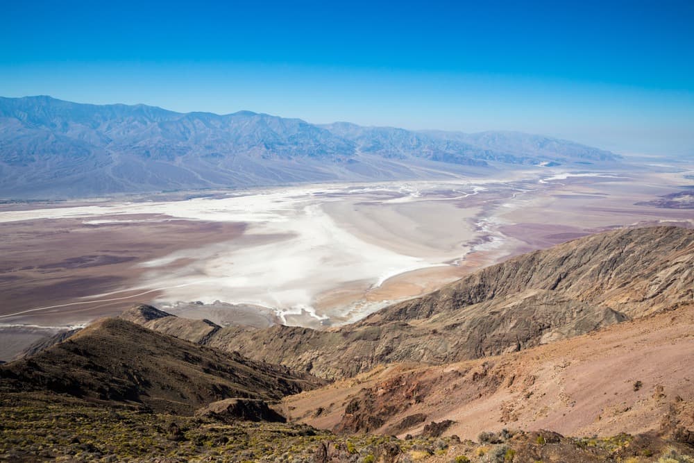
Perched at 1,669 meters altitude in the Black Mountains, Dante's View overlooks Death Valley and offers numerous viewpoints from its vantage point, including:
● Badwater Basin,
● Mount Owlshead,
● Funeral Mountains,
● Telescope Peak,
● Devil's Golf Course,
● Mount Whitney (on clear days).
Due to its geographical location (far from light pollution) and altitude, Dante's View is also an ideal spot for stargazing and enjoying the Milky Way. Occasionally, astronomy-related events are organized here.
This natural viewpoint is accessible by car, but be careful: the road climbs steeply and your car's engine can quickly overheat. In fact, it's prohibited for large vehicles like RVs.
Artist's Palette
Located along the Artist's Drive loop and stretching 14.5 kilometers, Artist's Palette is a one-way route that will reveal incredible landscapes of colored strata, resulting from the natural oxidation of rocks and metals.
On the agenda? Landscapes in ochre, pink, and mauve tones, like full-scale paintings that gave Artist's Palette its name. The best time to admire the colors is late afternoon, when the sun descends and accentuates the contrasts of the different hues.
The site is accessible by car (except heavy vehicles), while a hiking trail allows you to get closer to the spot.
Devil's Golf Course
Devil's Golf Course is situated on a vast former crystallized salt deposit.
The site owes its name to a note in the guide issued by the National Park Service, which wrote that "Only the devil could play golf on such a course"! Here, you'll discover a chaotic landscape, sculpted by the evaporation of an ancient salt lake…
The ground is hard, uneven, and especially sharp, so it's strongly discouraged to venture too far to avoid injury (as the formations are also unstable). In dry conditions, you can sometimes hear salt crystals pop due to the heat!
In case of rain, the access road to Devil's Golf Course may be closed.

Golden Canyon and the Red Cathedral
A crossing of Golden Canyon is among the main attractions of Death Valley. Composed of sedimentary rocks, the canyon stretches for over 5 kilometers. The site is explored on foot (with a hiking trail starting from a parking area on Badwater Road). The hike is quite easy and allows you to observe the golden hues of this part of Death Valley.
At first, the trail is fairly narrow, then opens up as you progress. After about 1.5 kilometers of gentle climbing, you'll reach the Red Cathedral: colossal red cliffs whose steep walls and vertical reliefs evoke the Gothic architecture of a cathedral.
Golden Canyon and the Red Cathedral can be explored via the Gower Gulch Loop.
Badwater, North America's lowest point
At an average altitude of 85.5 meters below sea level, it's the lowest point of all North America. There's a vast expanse consisting of a basin of non-potable water (hence its name "Badwater") fed by a spring on which lies a salt bed.
Despite relatively hostile living conditions, the basin forms the habitat for a few animal and plant species such as pickleweed, aquatic insects, and Badwater snails.
Discover the beauty of Death Valley on the American West highlights route !
Are there circuits to visit Death Valley?
Death Valley offers several hiking loops, including:
● Gower Gulch Loop,
● Badlands Loop Trail,
● Salt Creek Loop Trail,
● etc.
How much time do you need to visit Death Valley?
Death Valley is divided into several zones (depending on the entrances), each hosting emblematic sites. It takes approximately one day to explore a single zone (or two, if they're located near each other).
You should also factor in your own heat tolerance, which can potentially limit time spent in Death Valley.
The entrance pass is valid for 7 consecutive days, allowing you to enter and exit the park unlimited times – and extend visits over several days.
Here's a non-exhaustive list of sites to see near the main entrances:
1. Northern Entrance – NV-267 (Scotty's Castle)
● Racetrack Playa,
● Big Pine Road,
● Ubehebe Crater
● Eureka Dunes
2. Northeastern Entrance – NV-374 (from Beatty)
● The ghost town of Rhyolite
3. Western Entrance – CA-190 via Lone Pine / Panamint Springs
● Mesquite Flat Dunes
● Rainbow Canyon
● Darwin Falls (waterfalls nestled in a canyon)
● Wildrose Charcoal Kilns
4. Eastern Entrance – CA-190 from Death Valley Junction
● Zabriskie Point
● Furnace Creek
● Artist's Drive & Artist's Palette
● Dante's View
5. Southeastern Entrance – CA-178 from Shoshone (Badwater Road)
● Devil's Golf Course
● Golden Canyon
● Badwater
Feel free to consult the official Death Valley Park map to locate site positions.

A note on entrances: which zones can be visited on the same day? Technically, it's possible to connect all zones during a single day. However, from a tourism perspective and to fully enjoy the sites, here's what's reasonably achievable: Zones that can be combined in one day: ● Northern + Northeastern Entrance ● Northeastern + Eastern Entrance ● Eastern + Southeastern Entrance Zones not combinable in one day (except for express traversal): ● Northern + Western Entrance ● Northern + Southeastern Entrance ● Western + Southeastern Entrance |
Practical information for visiting Death Valley
How do you access the park?
There are many roads leading to Death Valley, but no official demarcation of different zones. The main entrances are:
● North (via NV267, Scotty's Castle route),
● Northeastern (via NV374, departing from Beatty),
● Western (via CA190 route, passing through Panamint Springs or Panamint Valley Road (from Searles Valley).
● Eastern (via CA190 route)
● Southeastern (via CA178 route), departing from Shoshone
All Death Valley sectors are connected to each other by several roads, the main one being CA190 (which crosses the park). Most sites are served by paved roads and thus fairly easily accessible.
Paved roads:
● CA 190 from Death Valley Junction, CA
● SR 374 from Beatty, NV
● CA 178 from Shoshone, CA
● SR 267 from US 95, NV
● CA 190 from Olancha, CA (SR 136 from Lone Pine, CA)
● SR 178 (Panamint Valley Rd) from Trona, CA
Secondary routes (dirt roads):
● Wildrose Canyon Road
● Harry Wade Road
● Titus Canyon Road
● Death Valley/Big Pine Road
● Saline Valley Road
What's the best time to visit Death Valley?
Death Valley experiences intense heat year-round, with a peak intensity in summer (particularly in August). If you don't tolerate heat well, it's best to avoid the summer season and visit the park during other seasons.
Here's the average daytime temperature by season:
● Winter 20°C
● Spring 32°C
● Fall 35°C
● Summer: temperatures can reach 50°C.
How much does park entry cost?
The entry price* to Death Valley National Park depends on your means of transportation, namely:
● Car $30/vehicle
● Motorcycle $25/vehicle
● On foot $15/person
Access is unlimited for 7 consecutive days (prices* valid as of June 2025).
What precautions should you take?
For a successful experience in Death Valley, it's important to be well equipped during your excursion.
● For people: have sufficient water, comfortable hiking shoes (not sandals due to the heat), and everything you need to protect yourself from the sun (SPF 50 sunscreen, sunglasses, hat). To avoid sunburn, wear long clothing and choose lightweight fabrics, like linen.
● For vehicles: rent a vehicle suited to your itinerary! While all vehicle types can drive on paved roads, certain parts of Death Valley require a 4x4, such as Racetrack Road (via Ubehebe Crater).
Obviously, opt for an air-conditioned vehicle and remember to fill up on gas (there are only 3 stations within the park and fuel is more expensive there than outside).
It's also recommended to have a paper map in the car, as GPS is unreliable once you leave tourist spots and main roads…
Where to stay in Death Valley? Death Valley is located near major cities and, since the park pass is valid for 7 consecutive days, it's entirely possible to stay outside the park. If you wish to stay within Death Valley, know that there are several hotels (quite expensive)... ● Stovepipe Wells Village, ● The Oasis at Death Valley, ● The Ranch at Death, ● Valley Panamint Springs Resort. … But also campgrounds (more or less upscale), including: ● Furnace Creek, ● Texas Springs, ● Sunset Campground, ● Stovepipe Wells, ● Wildrose, ● Etc. Caution: some establishments are not open year-round. |
Frequently asked questions
What's the highest temperature ever recorded in Death Valley?
The highest temperature ever recorded in Death Valley (and on Earth) was noted in July 1913, in the Furnace Creek area, reaching 56.7°C! In August 2020, the record was nearly matched in the same part of the park, with temperatures reaching 54.4°C!
Are there guided tours of Death Valley?
Death Valley can be visited with or without a guide. Specialized tour operators offer excursions (ranging from a few hours to a full day) that allow you to discover the must-see sites of the famous valley. The price typically includes vehicle rental, park entry, and meals.
Why is Death Valley dangerous?
Death Valley is dangerous because of the heat. It's not uncommon for visitors to lose their lives there due to extreme climate conditions. While it's a very touristy site, this part of the États-Unis remains a desert region that requires good preparation.
Frequently asked questions
The best time to visit Death Valley is winter or spring, when temperatures are milder (around 20-32°C). Summer is best avoided, especially in August, when temperatures can exceed 50°C, making outdoor activities dangerous.
Ideally, you should plan 3 to 4 days to visit the main Death Valley sites. Since the entrance pass is valid for 7 consecutive days, you can organize your visit over multiple half-days by geographic zone (north, east, southeast), while staying outside the park if you wish.
Death Valley is approximately 250 km from Las Vegas, a drive of about 2.5 hours via US-95 then NV-374 (northeastern entrance via Beatty). This is the most common route for travelers departing from Las Vegas.
Most major Death Valley sites are accessible with a standard vehicle (air-conditioned car), as they're served by paved roads. However, some sites like Racetrack Playa require an SUV or 4x4 with good ground clearance to drive on dirt tracks.
Entry to Death Valley National Park costs $30 per vehicle (car), $25 per motorcycle, and $15 per person on foot (rates in effect as of June 2025). This pass is valid for 7 consecutive days, allowing you to enter and exit the park as many times as you wish.
Yes, it's possible to camp in Death Valley. The park has several campgrounds, including a primitive campground near the Eureka Dunes (without amenities). Some sites are reservable in advance, while others are available on a first-come, first-served basis. Be sure to check conditions and availability on the National Park Service official website before your departure.
