Horseshoe Bend
Horseshoe Bend
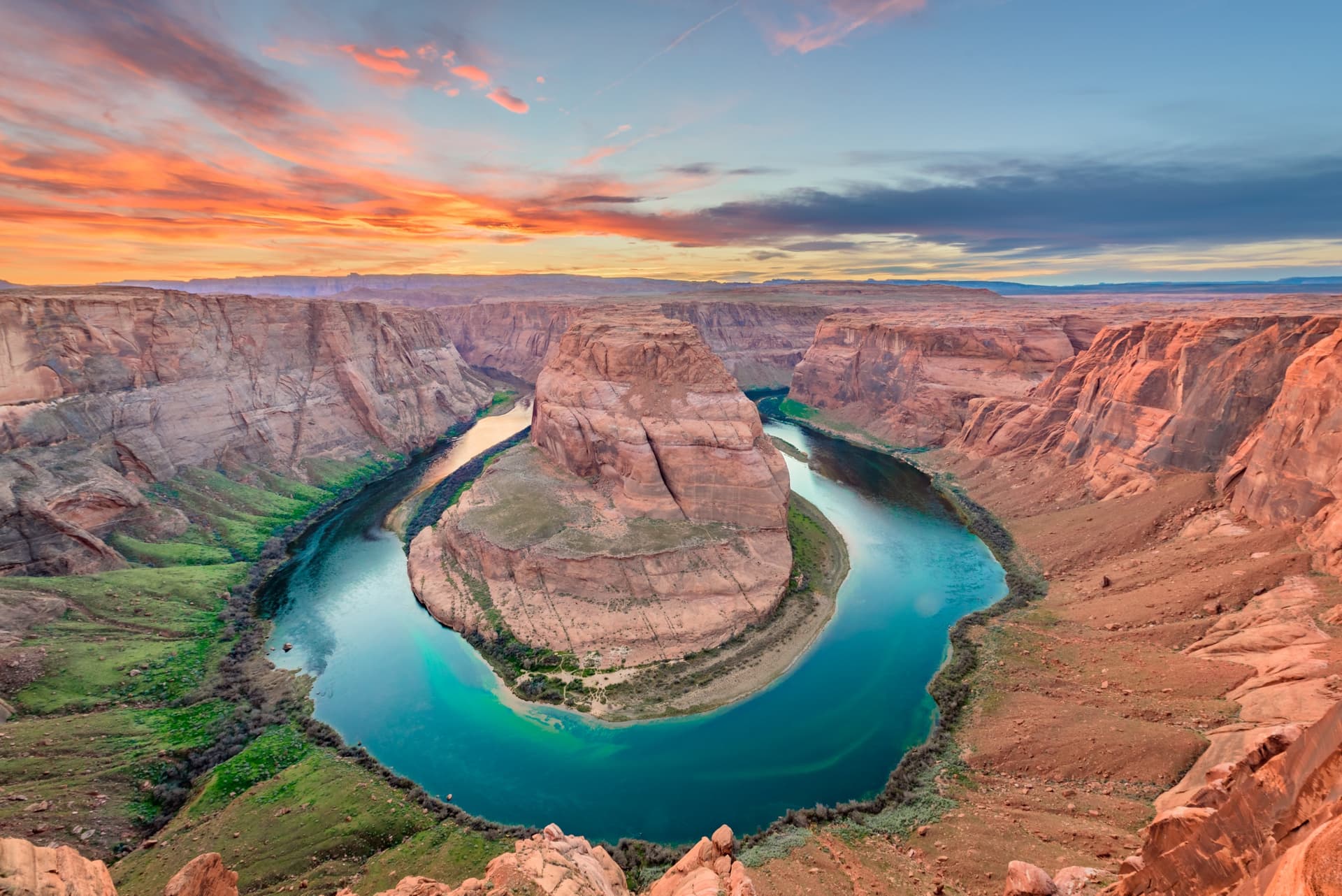
Just a few kilometers from Page, Arizona, Horseshoe Bend traces a horseshoe-shaped meander carved by the Colorado River, observable from a scenic overlook.
Just a few kilometers south of the town of Page, Arizona, Horseshoe Bend traces a horseshoe-shaped meander carved by the Colorado River. The site, freely accessible from a parking area near US Route 89, attracts hundreds of thousands of visitors each year who come to observe the perfect curve of the river from an overlook situated approximately 300 meters above the water.
Why Visit Horseshoe Bend
Horseshoe Bend offers one of the most recognizable geological panoramas in the American Southwest. Its singularity stems from three elements: the almost perfect shape of the meander, the contrast between red sandstone cliffs and the deep green of the Colorado, and the easy access from Page. Unlike most of the spectacular viewpoints around the Grand Canyon or Bryce, you reach the overlook in about thirty minutes of walking, with no permit or entrance fee required. The site lends itself to a short visit (1-2 hours) that you can combine with other attractions in the region around Lake Powell.
History and Geology of the Site
Horseshoe Bend is what geologists call an incised meander. Its formation spans approximately six million years. Originally, the Colorado River wound its way at low altitude through plains. The progressive uplift of the Colorado Plateau caused the river to cut deeper into the rock: instead of changing its course, the river continued to cut vertically, maintaining its initial curve while carving a canyon several hundred meters deep.
This erosion dynamic, combined with the soft nature of Navajo sandstone, explains the sharp profile of the meander. The site, long known only to locals and specialized photographers, became a major tourist destination starting in the 2010s, which led the town of Page to develop the current parking area and access trail.
What to See and Do
The Main Overlook
Access is via a sandy trail of about 1 kilometer from the parking area, with a gentle slope. Allow 30 minutes to 1 hour round-trip depending on your pace and how busy it is. A viewing platform secured by a railing has been set up at the main viewpoint: this is the recommended spot for families with children, as the cliffs drop straight down toward the river.
Other viewpoints, unsecured, line the canyon's edge. The smooth sandstone can be slippery, especially after rain, and caution is necessary if you approach them.
Helicopter Tours
Several operators offer helicopter flights from the helipad located near Lake Powell. The flight typically lasts 30 to 40 minutes and includes the meander, Glen Canyon Dam, and part of the lake. Advance booking is recommended during peak season.
Colorado River Navigation
Boat and kayak excursions allow you to paddle up the Colorado River from Lee's Ferry and view the meander from the water. These outings often last a full day and can be combined with visits to the Glen Canyon Dam and the Vermillion Cliffs.
Practical Information
- Site access: free.
- Parking: paid, managed by the town of Page (moderate fee, payable on-site). It is not covered by the America the Beautiful pass.
- Hours: sunrise to sunset, year-round.
- Recommended equipment: closed-toe shoes (sand gets very hot in summer), plenty of water, hat, sunscreen. No water sources or shops on the trail.
- Safety: stay behind railings with young children, watch your camera gear near the edge.
When to Visit
The site is open year-round, but the experience varies significantly by season.
- Spring (March-May) and autumn (September-October): pleasant temperatures, soft light, optimal conditions for hiking and photography.
- Summer (June-August): intense heat (often exceeding 95°F), scorching sand, maximum crowds. Favor very early morning or late afternoon.
- Winter (November-February): few visitors, cool temperatures, possible snow. Low-angle light that's interesting for photography.
For photography, the late afternoon before sunset offers the warmest light on the cliffs. Midday lighting better illuminates the meander's interior but flattens the relief. Crowds are heavy between 9am-11am and 4:30pm-6:30pm; visiting in early afternoon helps you avoid peak times, provided you can tolerate summer heat.
How to Get There
From Page
Horseshoe Bend is located just south of Page via US Route 89. Look for mile markers 544 and 545: the developed parking area is located at this spot. From there, the overlook is reached on foot in about twenty minutes via the sandy trail.
From Las Vegas
Las Vegas International Airport is the most convenient hub for international travelers. Expect approximately 4.5 to 5 hours of driving to reach Page. Many visitors incorporate Horseshoe Bend into a larger circuit that includes the Grand Canyon, Antelope Canyon, and Monument Valley.
What to See in the Region
The Page area is perfect for a multi-day stay. In the immediate vicinity, the Glen Canyon Dam, Lake Powell, and Antelope Canyon naturally complement your visit. Expanding slightly, you can reach the Bryce Canyon National Park and its hoodoos, or Canyonlands National Park for other landscapes shaped by the Colorado. Further east, Cadillac Ranch in Texas makes an original stop along Route 66. Cave enthusiasts will appreciate Cave of the Winds in Colorado.
Frequently asked questions
The walls rise approximately 300 meters above the Colorado River, which explains the vertiginous character of the overlook.
Entry to the site is free. Only parking is paid, managed by the town of Page. It is not included in the America the Beautiful pass.
The 1-kilometer trail has a gentle slope but sandy ground that can be challenging in intense heat. An accessible ramp facilitates the journey for people with reduced mobility up to an intermediate viewpoint.
Late afternoon, before sunset, offers the best light on the cliffs. Midday lighting prevents deep shadows in the meander. A wide-angle lens is recommended to frame the entire curve.
Allow 1 to 2 hours total, including parking, overlook, and return. A longer visit is rarely necessary unless you're waiting for particular lighting for photography.
Plan Your Trip
Horseshoe Bend integrates beautifully into a circuit through the American West combining national parks, Native American sites, and Route 66 towns. To build a custom itinerary, consult our travel suggestions for the États-Unis.
Interested in this visit?
We can include it in your personalised itinerary.